【Chapter 0】 The Medieval Defense Line: Castles of Shimosa and the Satsuma Castle Ruins
Era: Late 15th Century to 16th Century (Sengoku / Warring States Period)
1. The Story of Kamagaya: A “Tense Boundary” Carved into the Earth
The Satsuma district, located in northern Kamagaya City, is now a peaceful residential area. However, 500 years ago, this was the “front line” where massive powers clashed in a struggle for supremacy over the Kanto Plain.
At that time, Shimosa Province was a complex border zone where various forces—including the Koga Kubo (Ashikaga clan), the rising Late Hojo clan, and the Chiba clan—were intertwined in conflict. In this environment, “Satsuma Castle” functioned not merely as a village shelter, but as a critical military stronghold. Its most remarkable feature is its strategic location.
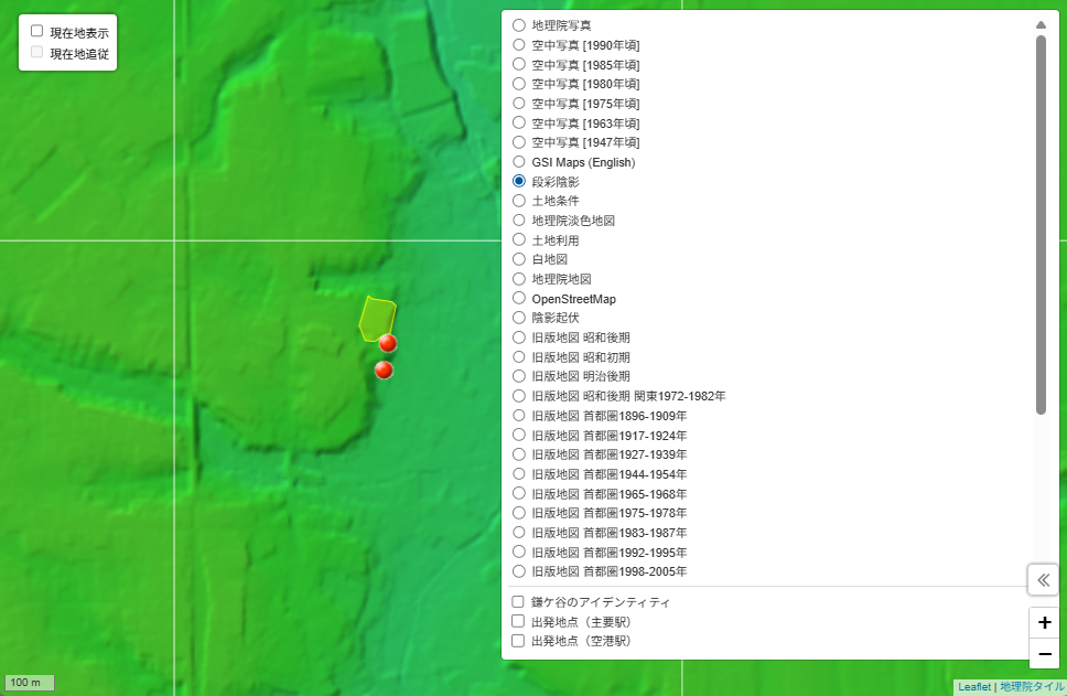
When visualized using Relief Maps (Shaded Relief Maps), the brilliance of its design becomes clear. Satsuma Castle was built on the tip of a plateau that thrusts like a finger into the Yatsu (valley wetlands). Surrounded on three sides by deep marshes and cliffs, and fortified on the remaining side with earthen ramparts and dry moats, it was a “rear-fortified” stronghold. This was a masterpiece of medieval wisdom, designed to repel a large force with only a small number of soldiers.
As you walk along the remains of the moats and ramparts that still exist today, you can almost feel the vivid tension the samurai once felt—gazing across the wetlands at an enemy approaching from the other side.
Recommended Links (External sites)
- Guide to Satsuma Castle: Shirobito (Castle Enthusiast Site) (Japanese site only)
- Kamagaya City History: Did you know Kamagaya had a castle? (Japanese site only)
- Cultural Properties: Satsuma Castle Ruins (Kamagaya City) (Japanese site only)
- Drone Footage: Satsuma Castle Ruins (@Koonada) (Visual content)
2. The World at That Time: The End of Knighthood and Global Expansion
During this same era, across the ocean in Europe, the “Age of Discovery” was unfolding. In 1492, Columbus reached the New World. Firearms were becoming the dominant force on the battlefield, signaling the end of the era of the heavily armored “Knight.”
While the samurai of Kamagaya were piling earth and digging moats to defend their “borders,” the world was beginning to connect via the sea, pivoting toward a new paradigm of modern nation-states. The earthen ramparts of Satsuma Castle stand as a pinnacle of Japanese feudal society, while simultaneously preserving the “silence” that preceded a global transformation.
Global Context
- Wikipedia: Age of Discovery
- Educational Video: World History: The Age of Discovery (Japanese audio/subtitles)
Reference Material: Shimosa Province (indicated in “Red” on the map of Japan)
To the Interactive Map
Historical Map Atlas: Exploring Kamagaya (Time Travel Map)
Note: As of March 2026, access is currently restricted by ID and Password. We are preparing for a server migration via crowdfunding to ensure the long-term preservation of these digital assets.
Created by: Reki-tabi Sha: Hiroaki Shirotae
Original Draft: Generative AI Gemini
Date Created: March 29, 2026 Last Updated: March 29, 2026


コメント